Project Sites

Our Site Locations
Lorem ipsum dolor sit amet, consectetur adipiscing elit, sed do eiusmod tempor incididunt ut labore et dolore magna aliqua. Ut enim ad minim veniam, quis nostrud exercitation ullamco laboris nisi ut aliquip ex ea commodo consequat. Duis aute irure dolor in reprehenderit in voluptate velit esse cillum dolore eu fugiat nulla pariatur. Excepteur sint occaecat cupidatat non proident, sunt in culpa qui officia deserunt mollit anim id est laborum.
Coordinates: 05 55’N 00 49’E
Area: 101,023 hectares (total area)
Through the Contracting Parties Convention of Wetlands, the Keta Lagoon Complex was designated a Wetland of International Importance (the “Ramsar List”). This Complex, comprised of multiple lagoons and small islands, is the largest lagoon in West Africa covering over 100,000 hectares of water and land area. The non-residential areas are dominated by mangroves, swamps, and scrubland.
The International Union for Conservation of Nature (IUCN) has listed multiple resident animal species within the complex area as threatened or endangered (Red List). Threatened species include the leatherback, olive and ridley turtles as well as the Nile monitor that use the lagoon area for nesting grounds. Also found within the complex is the West African Manatee and over 70 bird species.
Although designated as an official RAMSAR site, the Keta Lagoon Complex biodiversity continues to be threatened by both climate change and anthropogenic activity of the burgeoning human population currently estimated at over 500,000.
The lack of financial support for adequate waste management and sanitation systems, sea erosion and mangrove forest exploitation for fuel and fishing continue to threaten the overall health of the ecosystem.3
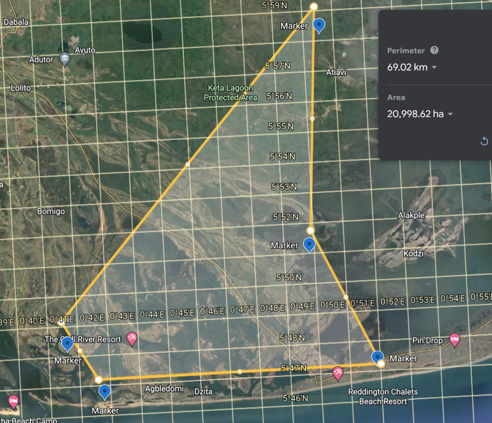
Coordinates: 05 45’N 00 30’E
Area: 51,113 hectares (total area)
Through the Contracting Parties Convention of Wetlands, the Keta Lagoon Complex was designated a Wetland of International Importance (the “Ramsar List”). Located west of the Volta estuary, the Songor Lagoon covers an area of over 50,000 hectares of marsh and grasslands with degraded mangrove forests and a coastal savannah that has been negatively impacted by local farming and grazing.
This area combined with the western area of the Volta estuary supports approximately 500,000 residents and is home to thousands of birds and marine animals. The majority of economic activity focuses on fishing, agriculture and tourism.
Threats to the long-term stability of the rich biodiversity stem from poor sanitation and waste management as well as coastal erosion and siltation within the river delta. Lack of financial resources and long-term planning constrains the ability of the community to support active restoration and maintenance of the ecosystem.4
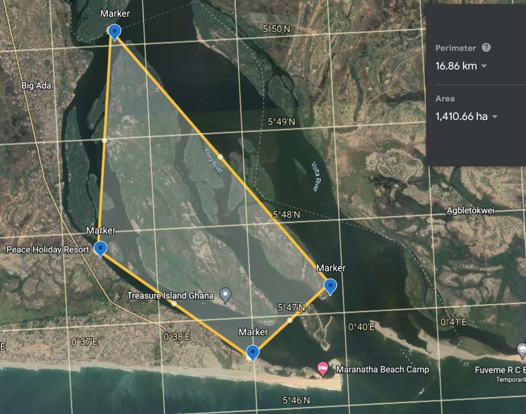
Coordinates – 5 47’N 0 38’E
Area approximately 1,500 hectares (limited area within 8,000 total hectares)
The island communities identified for project implementation are Azizakpe, Aflive, Alokpem, Pediatorkorpey, Kewuse, and Alorwusiodekorpey, and were chosen based on the guidance of the Ada Wildlife Division of the Forestry Commission. The island communities in the Volta delta suffer from a myriad of problems which threaten to pull them under.
Often, small but dangerous rivers form in townships which separate students from their schools and workers from their shops. Roadways are destroyed and buildings are damaged forcing residents to relocate or endure increasingly challenging environmental conditions. Yet many stay because these islands are home to communities which are hundreds of years old and have been built through the love and dedication of generations. The culture is rich with life, the economy is unique, schools, clinics and community centers have been built in honor of development, and tourists often come to learn about their way of life and enjoy the breathtaking environment.
In the case that nothing is done to mitigate the problem of flooding and erosion in the Volta delta there will be massive displacement of island residents. Unabated flooding and erosion will worsen and expand upstream causing widespread river salinization; threatening upstream islands, ecosystems and the riverside of Ada and Keta as the ocean continues to rise with nowhere else to go.
Volta Revival Foundation, a project partner, has worked closely with local community members for over six years. To support their mission of reducing the incidence of child slavery, they propose a three-step solution to address not only the problem of flooding and erosion in the Volta delta, but also to develop economic opportunities for community members to support sustainable change and healthy living conditions:
- Partner with local communities to educate about the importance of human activity for environmental sustainability, provide training for mangrove/coconut tree planting, sanitation awareness, animal penning strategies, and provide pure water filters to the community.
- Partner with the communities to reforest their mangrove wetlands and establish an annual planting schedule based on the seasons.
3. Partner with the communities to establish a perimeter of multiple rows of coconut trees and support coconut oil producers with a coconut tree nursery and planting schedule.